
If you are planning a fence, shed, pool or addition, the first question is where your lot actually ends. You can find property lines yourself with surprising accuracy using documents you probably already have, but each method has limits, and some projects need a licensed surveyor to settle the question.
Quick answer: Start with your recorded plat or an existing survey to get the lot dimensions. Then find the corner markers, usually iron rods or pipes near each corner, and measure between them to confirm they match the plat. County GIS maps help you get oriented but are approximate. If markers are missing, disputed or your project sits close to a line, hire a licensed land surveyor.
Method 1: Read your plat
If your home is in a subdivision, a surveyor drew a plat when the lots were created, and it is on file with the county recorder. The plat gives each lot’s dimensions, bearings and recorded easements. It is the single best document for understanding your lot’s shape and size.
Method 2: Check your survey or closing documents
Many purchases include a survey or mortgage inspection drawing. A boundary survey shows the lines precisely; a mortgage or location survey shows the house in relation to them but is less authoritative. Our guide on using an old survey explains how to tell which you have.
Method 3: Find the corner markers
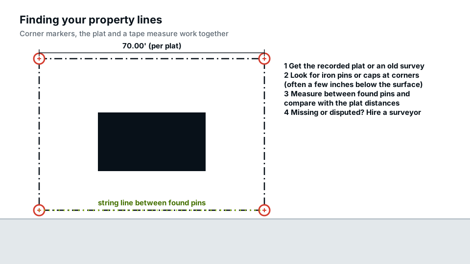
Surveyors mark corners with monuments, most often a steel rod or pipe driven into the ground, sometimes with a plastic or aluminium cap stamped with a licence number. Over time they get buried under a few inches of soil or turf.
- Use the plat dimensions to estimate where each corner should be.
- Look near fence corners, driveway edges and sidewalk joints.
- A basic metal detector finds buried rods quickly.
- Probe gently; don’t pull or move a marker. Disturbing a survey monument can be illegal in some states.
Method 4: Measure and compare
Once you find two or more markers, measure between them with a long tape and compare with the plat. If the distances match within a few inches, you can be reasonably confident the markers are original. Stretch a string line between them to see the boundary on the ground. If they don’t match, a marker may have been moved or replaced, and you should not rely on it.
Method 5: Use the county GIS map, carefully
Most counties publish an online parcel map. It is excellent for finding your parcel number, lot shape, zoning and approximate size. It is not survey-grade: parcel lines can be shifted several feet from their true position, especially in older areas. Use GIS to get oriented, not to place a fence.
Method 6: Hire a licensed land surveyor
A surveyor is the only person who can establish the legal boundary and set new markers. Hire one when markers are missing, when a neighbour disagrees, when you plan to build on or very near the line, or when a permit office or lender requires a survey. The difference between drafted records and a field survey is covered in our pillar guide on site plan vs survey.
How accurate is each way to find property lines?
| Method | Accuracy | Good enough for |
|---|---|---|
| Boundary survey | Highest, legally reliable | Building on or near the line, disputes |
| Found original markers + plat | Usually good | Fences inside the line, sheds, decks |
| Plat dimensions alone | Shape and size, not position on the ground | Drafting a site plan |
| County GIS map | Approximate, can be off by several feet | Orientation, early planning |
| Existing fences and hedges | Unreliable | Nothing on its own |
What to do if a neighbour disagrees
If you and a neighbour see the line differently, stop before building anything near it. Share the documents you each have, such as plats, surveys and deeds; often the answer is in the paperwork. If it isn’t, a licensed surveyor can establish the line, and some neighbours agree to split the cost. If the disagreement continues after a survey, a real estate attorney can explain your options. A fence or shed built in the wrong place is much harder to fix later than a conversation now.
Mistakes to avoid
- Assuming the fence is the line. Fences are often built a little inside or outside the boundary.
- Measuring from the curb or sidewalk. The front property line is usually some distance behind the curb, at the edge of the public right-of-way.
- Relying on GIS for work at the setback limit.
- Moving a marker you find. Leave it for the surveyor.
Showing property lines on your permit drawings
For a permit, the property lines on your site plan should come from the best source you have, and that source should be named on the sheet. A site plan drafted from your plat or survey gives the reviewer the distances they need, while a survey is reserved for the cases where the boundary itself is in question.
Frequently asked questions
Can I find my property lines online?
You can find approximate lines on your county’s GIS parcel map, and often your plat through the county recorder. Neither replaces a survey for work right on the line.
What do property line markers look like?
Usually a steel rod or pipe in the ground, sometimes with a plastic or metal cap stamped with a surveyor’s licence number. They are often buried a few inches deep.
Is it legal to move a survey marker?
No, many states prohibit disturbing survey monuments. If one is in the way of a project, ask a surveyor.
Where does my front property line start?
Usually at the edge of the public right-of-way, which is often several feet behind the curb or past the sidewalk, not at the curb itself.
Can an app or GPS find my property lines?
Phone apps and consumer GPS combine approximate parcel data with location accuracy of several feet. They are handy for a rough idea, but not for placing a fence or structure near the line.