
A site plan is a scaled, top-down drawing of a property that shows the lot lines, every building on the lot and the new work you want to build, with the distances between them. If you are applying for a permit for a deck, fence, pool, shed, garage, addition or new home, a site plan is usually the first drawing the permit office asks for, and the one most often sent back for corrections.
Quick answer: A site plan is a bird’s-eye drawing of your whole lot, drawn to scale. It shows property lines, existing buildings, the proposed work and the distances from that work to each lot line. Building and zoning offices use it to check setbacks, lot coverage, easements and access before they issue a permit.
Key takeaways
- A site plan shows the whole lot from above; a floor plan shows the inside of one building.
- Reviewers mainly use it to check setbacks, lot coverage, easements and drainage.
- It is not a boundary survey, and it does not prove where your property lines are.
- Most rejections come from a handful of missing items: setback dimensions, scale, north arrow and labels for new work.
- Requirements vary by city and county, so always start from your local checklist.
What is a site plan?
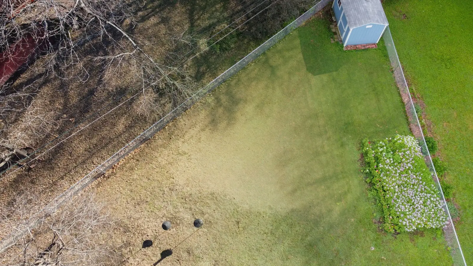
Think of a site plan as a map of a single property. It is drawn looking straight down, as if from a drone, and it is drawn to a stated scale so that anyone can measure distances from it. Where a floor plan zooms into the rooms of one building, a site plan zooms out to show everything inside the property lines: the house, the garage, the driveway, the fence, the pool, the shed and whatever you are proposing to add.
The purpose is simple. Before a building department lets you build, it needs to know where the new work will sit and whether that location follows the zoning rules for your lot. The site plan is the document that answers that question.
You will also hear site plans called plot plans, plot maps, lot plans or site layouts. In many places these words mean the same thing; in some, a “plot plan” is a simpler sheet. We explain the difference in our guide to site plan vs plot plan.
What does a site plan show?
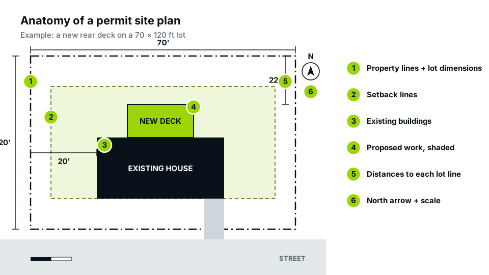
A permit site plan has a core set of information that almost every jurisdiction expects. Use this as a checklist before you submit:
- Property lines with their lengths, so the lot can be matched to the county record.
- Street names and the property address, with the street frontage clearly shown.
- Existing buildings and hard surfaces: house, garage, sheds, driveway, patios and walks, labelled as existing.
- The proposed work, shaded or hatched and labelled as new, with its size.
- Setback distances: the measurement from the new work to each property line.
- Setback lines for your zoning district, where the reviewer expects them.
- Easements and utilities near the work, such as recorded easements, septic systems, wells and overhead lines.
- North arrow and scale, ideally with a graphic scale bar.
- A title block with the address, parcel number, date and who prepared the drawing.
Depending on the project and the county, reviewers may also ask for a lot coverage calculation, impervious surface totals, the flood zone, drainage arrows, tree locations, parking spaces or the location of pool equipment. A good rule is that the plan should answer every question the reviewer would otherwise have to ask you.
Why do building departments require a site plan?
A building permit review has two halves. The building code half asks whether the structure is safe. The zoning half asks whether the structure is allowed in that spot. The site plan serves the zoning half, and it lets the reviewer confirm several things quickly:
- Setbacks: is the new work far enough from the front, side and rear property lines?
- Lot coverage: will the lot exceed the maximum share that can be covered by buildings or hard surfaces?
- Easements: does the work sit on a recorded easement for utilities, drainage or access?
- Separation: is a new structure far enough from the house or other buildings?
- Drainage and flood risk: will water be directed onto a neighbour, and is the lot in a mapped flood zone?
- Access: can the property still be reached by vehicles and emergency crews?
Without a site plan, a reviewer would need to visit the property to answer these questions. A clear drawing replaces that visit, which is why incomplete site plans are one of the most common reasons permits stall.
Which projects need a site plan?
Almost any project that changes the outside footprint of a property will need a site plan, and many permit offices require one even for small work. Typical examples:
| Project | Site plan usually needed? | What reviewers focus on |
|---|---|---|
| Deck or porch | Yes, in most places | Distance to rear and side lines, height above grade |
| Fence | Often | Fence line, height in each yard, corner sight triangle |
| Pool or spa | Yes | Setbacks, safety barrier, equipment location |
| Shed or accessory building | Often, above a size threshold | Size, setbacks, distance to the house |
| Garage, carport or addition | Yes | Setbacks from new walls, lot coverage |
| ADU or new home | Yes, as part of a full set | Setbacks, coverage, parking, utilities |
| Driveway or patio | Sometimes | Impervious area, curb cut, drainage |
Whether you need a permit at all depends on size and local rules. Our project pages, such as the deck permit drawings guide, list what counties usually ask for.
Site plan vs plot plan vs survey vs floor plan
These four documents are often confused, and ordering the wrong one is a common and expensive mistake.
| Document | What it shows | Who prepares it |
|---|---|---|
| Site plan | The whole lot, buildings, new work and distances | A drafter, designer, architect or engineer |
| Plot plan | Usually the same as a site plan; sometimes simpler | Same as a site plan |
| Boundary survey | The legal boundary, measured in the field, with corner markers | A licensed land surveyor |
| Floor plan | The rooms, walls and openings inside a building | A drafter, designer or architect |
The most important distinction is between a site plan and a survey. A survey establishes where the property lines are. A site plan uses that information, or the county’s parcel record, to show where the project goes. When a permit office specifically asks for a survey, a drafted site plan will not satisfy it. Our pillar guide on site plan vs survey explains when each one is required.
What scale is a site plan drawn at?
Residential site plans are usually drawn at an engineer’s scale, where one inch on paper equals a round number of feet. One inch equals 10, 20 or 30 feet are common, chosen so the whole lot fits on the sheet. Larger rural parcels may use 1 inch = 50 or 100 feet.
Two things matter more than the exact number: the scale must be stated on the sheet, and the drawing should include a graphic scale bar so it still measures correctly if the PDF is printed at a different size. We cover this in detail in site plan scale explained.
Where does the information on a site plan come from?
A site plan is only as accurate as the information behind it. Most permit site plans are drafted from a combination of these sources:
- A boundary survey or recorded plat: the most reliable source for lot lines and dimensions.
- County parcel maps and GIS data: useful for lot shape and approximate dimensions, but not survey-grade.
- Aerial imagery: helps locate existing buildings, driveways and trees.
- Deeds and title documents: for easements and access rights.
- Your own measurements and photos: for things the records do not show, such as a new patio or an old shed.
A good site plan names its sources in the title block, and states that it is not a boundary survey. That honesty helps reviewers trust the drawing, and it protects you if a dimension is later questioned.
How to read a site plan
If you have received a site plan, or you are checking one before submitting, read it in this order:
- Find the north arrow and the scale, so you know how the drawing is oriented and how to measure it.
- Trace the property lines and check their lengths against your deed, plat or survey.
- Identify the street and the front of the lot.
- Find the proposed work and confirm its size matches your plans.
- Check the distance from the new work to each property line against your zoning setbacks.
Symbols and line types vary between drafters, so our step-by-step guide on how to read a site plan walks through the common ones.
Easements and other constraints a site plan should show
An easement is a recorded right for someone else, such as a utility company or a neighbour, to use part of your property. You can usually landscape over an easement, but permanent structures such as sheds, pools and additions are normally not allowed on it. Reviewers check easements carefully because building on one can mean the structure has to be removed later.
Other constraints worth showing include septic tanks and drain fields, wells, overhead power lines, slopes, protected trees and mapped flood zones. Our guide to what an easement is explains the common types and where to find them.
How to get a site plan for your permit
You have four realistic options:
- Draw it yourself. Some permit offices accept a neat, scaled homeowner drawing for simple projects. It works best when you already have a survey to trace.
- Order a drafted site plan. A drafting service prepares the plan from your address, county records and any documents you have, without a site visit. This is the usual route for decks, fences, pools, sheds and additions; it is what our site plan service provides.
- Hire a land surveyor. Necessary when the permit office requires a survey, when the work is close to a disputed line, or in states where only surveyors may locate property lines, such as California.
- Use your architect or engineer. If you are building a new home or a large addition, the site plan is usually part of their full drawing set.
Common site plan mistakes that delay permits
Reviewers send site plans back for the same reasons again and again. Avoid these and most plans pass on the first review:
- No distance shown from the new work to one or more property lines.
- No scale, or a scale that does not match the drawing.
- No north arrow.
- New and existing structures drawn the same way.
- Recorded easements or septic systems left off.
- Lot coverage not calculated where the code limits it.
- A lot shape that does not match the county parcel record.
If your plan has already been returned, our guide on why building permits get rejected explains how to read the comments and fix them.
Frequently asked questions
Is a site plan the same as a survey?
No. A survey is a licensed field measurement that establishes your property lines. A site plan is a scaled drawing of the lot and the proposed work, usually drawn from a survey or county records. Some permits accept a site plan; others require a survey.
Can I draw my own site plan for a permit?
Often yes, for simple projects, as long as it is drawn to scale and shows everything on your county’s checklist. Many offices reject freehand sketches, so check the requirements first.
How long is a site plan valid?
A site plan does not expire on its own, but it must show the property as it is when you apply. If buildings have been added or removed since it was drawn, it needs updating.
What size paper should a site plan be?
It depends on the permit office. Letter or 11 × 17 inch sheets are common for small residential projects, and 24 × 36 inch sheets for larger ones. Many offices now accept PDFs through an online portal.
Does a site plan need to be stamped?
Most residential site plans do not need a stamp. Some jurisdictions require a surveyor’s or engineer’s seal for certain work, such as grading, drainage or projects near property lines.