
An elevation certificate is a FEMA form that documents the elevations of a building, such as its lowest floor, garage floor and equipment, relative to the base flood elevation and surrounding ground. It is completed by a licensed surveyor, engineer or architect. Floodplain permits use it to verify that construction meets elevation requirements, and flood insurers use it to rate policies.
Quick answer: An elevation certificate (EC) is FEMA’s form recording a building’s key elevations, its flood zone and base flood elevation, and details of enclosures and flood openings. It is completed by a licensed land surveyor, engineer or architect. Communities often require ECs for new construction and substantial improvements in flood zones, and insurers use them to price flood insurance.
What an elevation certificate records
| Section | Information |
|---|---|
| Property | Owner, address, parcel, building use |
| Flood map data | Community, FIRM panel, zone, BFE, datum |
| Building elevations | Top of bottom floor, next higher floor, garage, lowest equipment, lowest adjacent grade, highest adjacent grade |
| Building diagram | Which FEMA diagram matches the foundation type |
| Enclosures and openings | Areas below the lowest floor, number and size of flood openings |
| Certification | Signature and seal of the licensed professional |
For how these elevations fit the rules, see our pillar on building in a flood zone.
The three stages of an elevation certificate
- Construction drawings: based on the design, before construction, to show the plan meets requirements.
- Building under construction: once the floor level is set, often before framing continues, so errors can be fixed early.
- Finished construction: after completion, recording as-built elevations for the final permit and insurance.
Communities decide which stages they require. The under-construction check is valuable, because a floor set too low is far easier to fix before the walls go up.
When you need an elevation certificate
- New buildings in a Special Flood Hazard Area.
- Substantial improvements and substantial damage repairs; see the substantial improvement rule.
- Additions in flood zones, in many communities.
- Flood insurance rating, especially for buildings in high-risk zones.
- Letters of Map Amendment, to show a building is above BFE.
- Property sales, where buyers want to understand flood insurance costs.
Who can complete one
A licensed land surveyor, professional engineer or architect authorised by state law to certify elevation information. Surveyors complete most ECs because they measure elevations on site against benchmarks. Some community officials complete limited sections in A zones without BFEs.
What the surveyor measures
- Establishes elevation from a benchmark in the same datum as the flood map.
- Measures the top of the lowest floor, garage slab and next higher floor.
- Measures the lowest and highest adjacent grade next to the building.
- Measures the lowest elevation of machinery and equipment.
- Counts and measures flood openings in enclosures.
- Photographs the building as the form requires.
Building diagrams
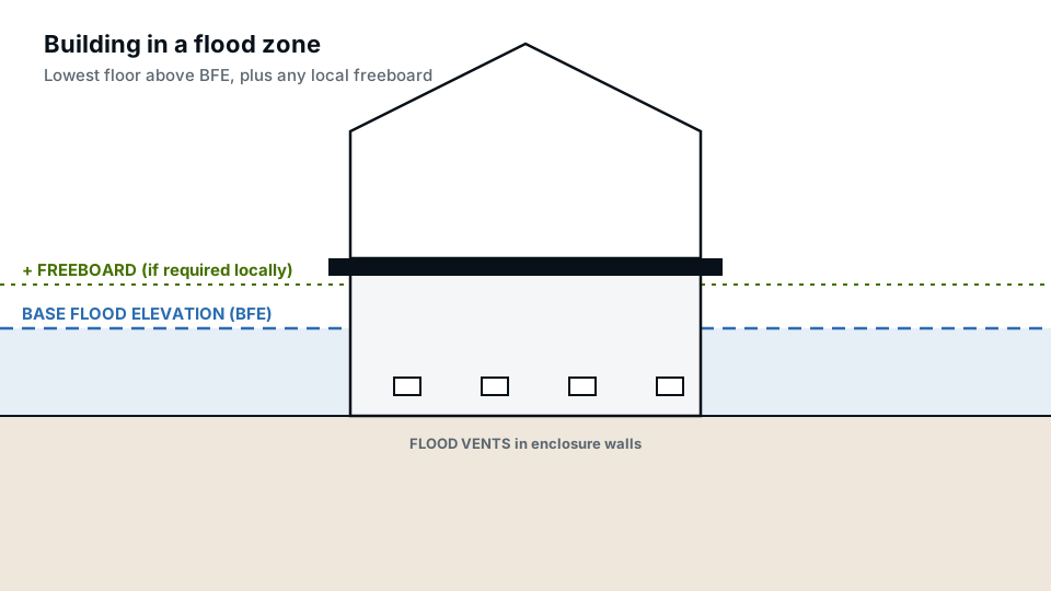
The form uses numbered diagrams to describe foundation types: slab on grade, basement, crawlspace, elevated on piers or piles, with or without enclosures. Picking the right diagram matters because it tells the reviewer and insurer which elevation is the “lowest floor”. An enclosed area below an elevated building that lacks proper flood openings can be treated as the lowest floor, with large consequences for compliance and insurance. See flood vent requirements.
How the certificate affects permits
Floodplain administrators compare the certified elevations with the required elevation (BFE plus freeboard). If the lowest floor or equipment is too low, the work doesn’t comply. Many communities withhold the certificate of occupancy or final inspection until a finished-construction EC is submitted.
How it affects flood insurance
Under FEMA’s current rating approach, elevation is one of several factors, but an EC can still help, especially for buildings elevated well above BFE. Lenders and insurers may ask for one. Keep a copy with your property records; it transfers with the building.
Finding an existing elevation certificate
Many communities keep copies of ECs for permitted buildings. Ask the floodplain administrator or building department, check with previous owners, or look in closing documents. If none exists or the building has changed, a new certificate is needed.
Elevation certificates and LOMAs
If a building is mapped inside the Special Flood Hazard Area but sits on ground above the base flood elevation, the surveyed elevations on an elevation certificate can support a Letter of Map Amendment from FEMA. If approved, the building is removed from the SFHA for insurance purposes, which may remove the lender’s insurance requirement. The surveyor typically prepares the elevation data, and the owner or surveyor submits the application. See how to find your flood zone.
Timing the survey
For new construction, schedule the surveyor at each stage the community requires. The under-construction certificate is most useful right after the floor or foundation is formed and before framing goes up, so that a floor set too low can be corrected cheaply. Coordinate the surveyor with your builder’s schedule so the inspection doesn’t hold up the work.
Common problems
- Datum mismatch between the map and the survey.
- Wrong building diagram selected.
- Equipment such as AC units below the required elevation.
- Enclosure without adequate flood openings.
- Waiting until completion to check elevations.
Planning with elevations in mind
Design the building with target elevations on the drawings: finished floor, garage slab and equipment platforms, each related to BFE and freeboard. Our site plans and elevation drawings can show these targets, which the surveyor then verifies.
Frequently asked questions
What is an elevation certificate?
A FEMA form documenting a building’s elevations relative to the base flood elevation.
Who can complete an elevation certificate?
A licensed land surveyor, engineer or architect authorised under state law.
Do I need an elevation certificate for flood insurance?
Not always, but it can help rate a policy and is often requested in high-risk zones.
Does an elevation certificate expire?
It remains valid for the building as certified unless the building or the flood map changes.
Can I get a copy of an old certificate?
Often from the community’s floodplain administrator or building department, or from the previous owner’s records.
How long does an elevation certificate take?
The survey visit is usually short; scheduling and completing the form can take days to weeks depending on the surveyor’s workload.